
Research
Our research at the Hydro- & Environmental Geophysics Lab (UToledo HEG-Lab) is focused on improving understanding of the variation in soil and aquifer properties as well as the hydrological and biogeochemcial processes within them. The shallow subsurface environment with depth ranging from a few to tens of meters below the surface is characterized by a high level of heterogeneity from pore to geologic scale. This results in high variability in spatial and temporal distribution of properties and processes within it. The implication of this is that the ability to predict the distribution of soil moisture and nutrients, groundwater flow, the fate and transport of chemicals, the engineering properties of soils as well as the location of ancient structures and buried objects within the shallow subsurface is limited. This is a constrain on the understanding, use and sustainable management of the shallow subsurface and its resources.
Hence, we use geophysical methods in combination with In-Situ (Direct-Push & Direct Sensing) and hydrogeological methods for improving the characterization of shallow subsurface heterogeneities as well as monitoring the state and processes within it; with applications for:
- soil and hydrological processes investigations
- biogeochemical processes and contaminated sites monitoring
- engineering, archaeological and forensic sites investigations
- and other environmental applications
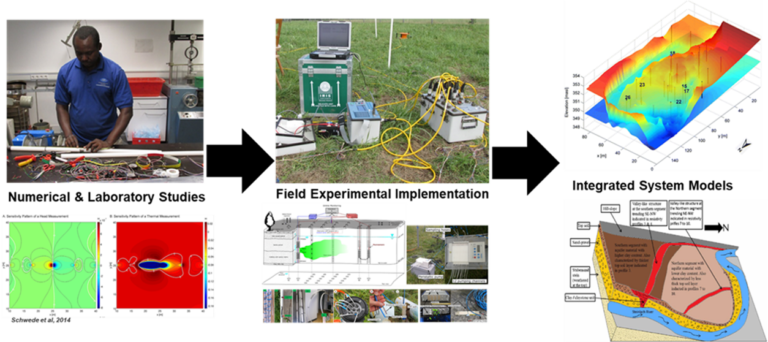
We combine both numerical and laboratory studies with field experimental implementations to obtain images of the shallow subsurface and estimates the needed hydraulic and biogeochemical parameters for developing and calibrating an integrated system’s model.
Major Research Areas :
- Soil Geophysics: Predicting the spatial and temporal distribution of soil physical and biochemical properties using geophysical methods including electromagnetic imaging, electrical resistivity, ground penetrating radar and self-potential.
- Hydrogeophysics: Improving estimates of aquifer flow and transport properties at a high spatial and temporal resolution and quantifying hydrostratigraphic controls on the propagation of hydrological and biogeochemical disturbances across terrestrial and aquatic interfaces.
- Forensic Geophysics: Imaging and quantifying geophysical anomalies associated with forensic targets such as buried weapons and human remains with the goal of improving the use of geophysical techniques as a non-destructive tool for locating clandestine buried weapons and graves.